Description
Features
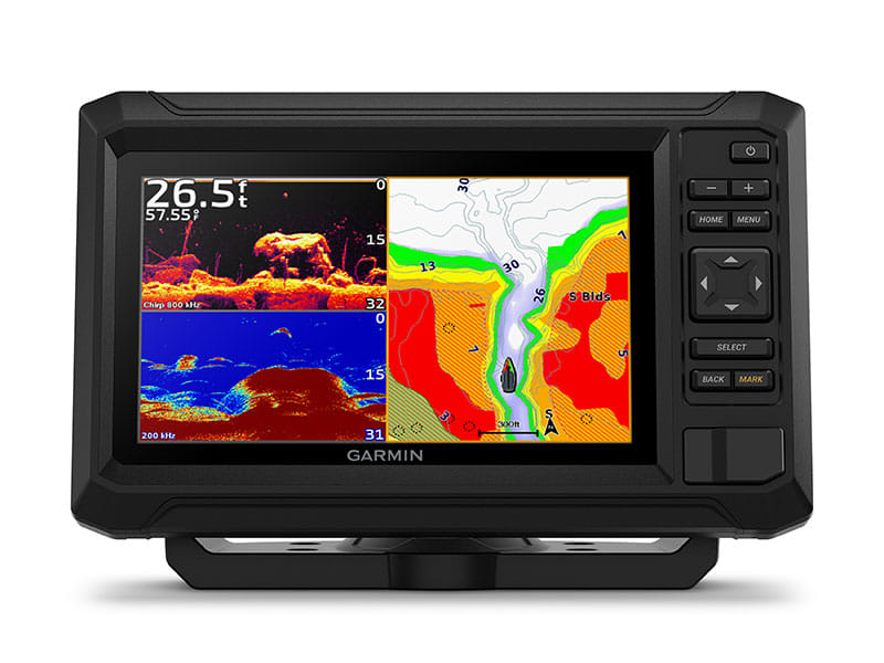
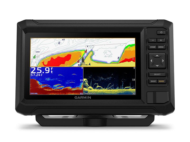
- Enjoy No. 1 in mapping with our Garmin Navionics+ (built in) and Garmin Navionics Vision+ (sold separately)
- The bright 7″ keyed display is made for convenience.
- Get double the views with Garmin CHIRP traditional and ClearVü scanning sonars.
- What’s under the water looks even better with high-contrast, vivid colour palettes.
- Wi-Fi connectivity2 between compatible chartplotters makes it easy to share info.
In the Box
- ECHOMAP Unit
- Power/data cable
- 8-pin to 4-pin transducer adapter cable
- Bail mount
- Flush mount
- Hardware
- Documentation
PRELOADED CHARTS
Know the waters you’re in as if you grew up fishing them by using built-in Garmin Navionics+™ charts or optional Garmin Navionics Vision+™.
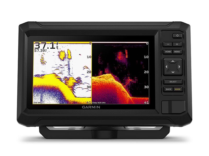
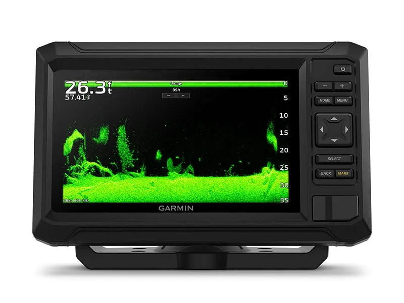
SONAR SUPPORT
With crisp, clear traditional sonar and brilliant ClearVü sonar, the fish will have nowhere to hide.
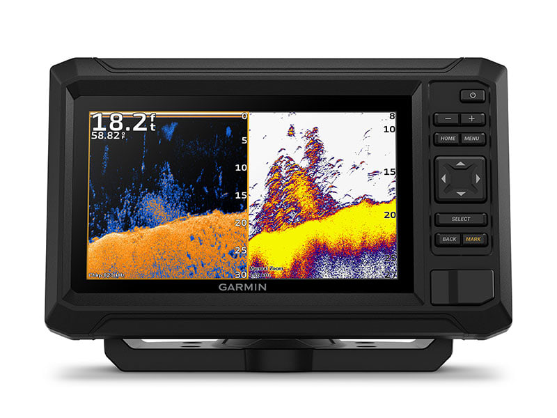
VIVID COLOUR PALETTES
High-contrast vivid scanning sonar colour palettes make it easier than ever to distinguish targets and structure.
BUNDLE YOUR TRANSDUCER
Your ECHOMAP UHD2 device supports a variety of Garmin transducers for two types of sonar: Garmin traditional and ClearVü scanning sonars.
WIRELESS NETWORKING
If you have another compatible ECHOMAP UHD2 chartplotter on your boat, the 5″ and 7″ models can wirelessly share information — such as sonar, waypoints and routes — with them.
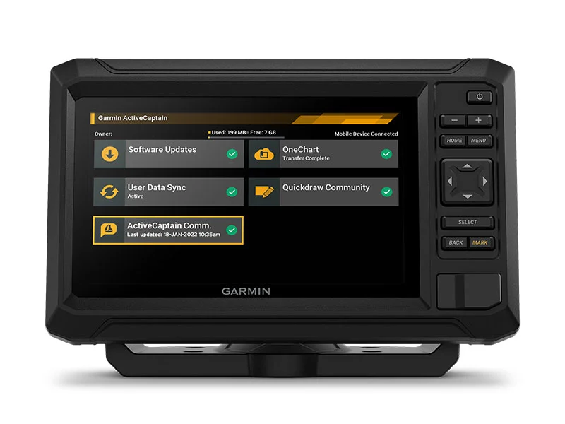
ActiveCaptain® App
Built-in Wi-Fi connectivity pairs with the free all-in-one mobile app for access to the OneChart™ feature, software updates, Garmin Quickdraw™ Community data and more2.
Specifications
Physical & Performance
| Display Size | 6.1″ x 3.4″ (15.5 x 8.7 cm) |
| Power Input | 9 to 18 Vdc |
| Display Resolution | 800 x 480 pixels |
| GPS | Yes |
| Dimension | 9.1″ x 5.6 x 2.6″ (23.2 x 14.3 x 6.7 cm) |
| Receiver | 5 Hz |
| Water rating | IPX7 |
| Weight | 1.5 lbs (0.7 kg) |
| Mounting Options | Bail or flush |
| Display Type | WVGA, TN |
Maps & Navigation
| Garmin Navionics+™ (Coastal) | Yes (see Additional) |
| Garmin Navionics Vision+™ | Yes |
| Accepts Data Cards | 1 microSD™ card; 32 GB maximum size |
| Garmin Navionics+ (Inland) | Yes (see Additional) |
| Navigation Routes | 100 |
| Garmin Navionics+™ | Yes |
Features
| Waypoints | 5000 |
| Sailing features | No |
| NMEA 0183 Compatible | No |
| Has built-in receiver | Yes |
| USB ports | No |
| TOPO | No |
| SideVü | No |
| DSC | No |
| Touchscreen | yes |
| Additional |
|
| LakeVü g3 Ultra | No |
| NMEA 2000® compatible | No |
| ActiveCaptain Mobile Planning Compatible | yes |
| Typical current draw at 12 Vdc | 1 A |
| Tide tables | No |
| GLONASS | No |
| Track points | 50000 |
| Panoptix™ sonar | No |
| LakeVü g3 | No |
| Supports WAAS | Yes |
| GSD Black Box Sonar Support | No |
| Maximum current draw at 12 Vdc | 1.5 A |
| Garmin SmartMode compatible (customisable monitor presets) | No |
| Built-in Auto Guidance | No |
| Maximum power usage at 10 Vdc | 18W |
| Standard Mapping | No |
| LakeVu (inland) | No |
| Displays sonar | Yes |
| ANT+ (Connectivity) | No |
| GCV Black Box Sonar Support | No |
| BNC external GPS antenna port | No |
| Spoken audio alerts | No |
| Garmin Wi-Fi network (local connection) | Yes |
| Input | Keyed |
| BeiDou | No |
| Garmin Quickdraw Contours | Yes |
| Bluetooth® calling | No |
| AIS | No |
| Supports multi-band, multi-constellation GPS | No |
| Raster chart support | No |
| 4-pin transducer ports | 1 |
| OneHelm support | No |
| ClearVü | Built-in 260/455/800 kHz |
| Tracks | 50 saved tracks |
| Wireless remote compatible | No |
| Supports Fusion-Link™ compatible radios | No |
| Galileo | No |
| LiveScope | No |
| Power output | 500W |
| BlueChart (coastal) | No |
| Traditional sonar (dual frequency/beam) | Built-in (single channel CHIRP, 70/83/200 kHz, L, M, H CHIRP) |
| GRID™ (Garmin Remote Input Device) compatible | No |
Related Products
Related Products


Garmin EchoMap 7" UHD2 75sv GPS with UK, IRL & NL Chart
Garmin


Garmin Echomap 5" UHD2 55cv with UK, IRL & NL Chart
Garmin


Garmin EchoMap 6" UHD2 65sv GPS with UK, IRL & NL Chart
Garmin


Garmin EchoMap 9" UHD2 95sv GPS with UK, IRL & NL Chart
Garmin


Garmin Echomap Plus 45cv w UK, IRL & NL Charts
Garmin