Description
The Garmin Echomap Plus 45CV GPS is the perfect combined GPS and Fishfinder unit from Garmin for use with all leisure craft, including RIBs and dinghies. This unit comes preloaded with Garmin G3 UK and Ireland coastal charts, giving you all the necessary details such as contours, depths, coastlines, and markers.
Features
- Bright, sunlight-readable 4.3-inch combo screen
- Preloaded BlueChart G3 for Ireland, UK, and Northern Europe
- Built-in Garmin Quickdraw Contours mapping software instantly creates personalised fishing maps on-screen as you fish
- Share waypoints and routes with other EchoMap or Striker Units
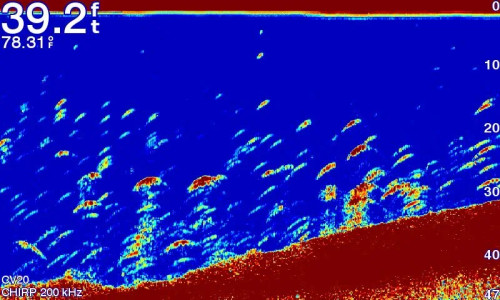
The Garmin CHIRP difference
The built-in sonar capabilities of ECHOMAP Plus 45cv include our CHIRP traditional sonar, one of the most sophisticated sonar technologies available for the fishing and boating public. CHIRP traditional sonar provides amazingly clear target separation and definition, because it puts even more energy onto the target than traditional sonar.
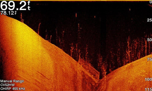
Clear scanning sonar images
Garmin CHIRP ClearVü scanning sonar gives you a nearly photographic image of what’s below your boat. You clearly see structure, submerged objects and fish.
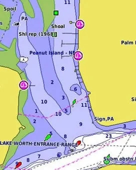
Preloaded BlueChart charts
Preloaded with highly detailed Garmin BlueChart mapping covering the British Isles in their entirety, including the Thames Estuary, Caledonian Canal, Outer Hebrides, Shetland and Orkney Islands, Isle of Wight, Isle of Man, Lough Neagh, The Shannon river (up to Lough Kee) and the Irish Sea. Continental coverage from Brest, FR to Kiel, DE including the Channel Islands, the Waddenzee, the IJsselmeer, the canals of The Netherlands, the Meuse River to Liege, BE; the Rhine River to Dusseldorf, DE and the Kiel Canal.
Quickdraw Contours to create your own maps
Instantly create personalised fishing maps on-screen, then tailor them to fit your needs. These are your maps — you own them. Keep the data to yourself, or share it with the Quickdraw Community on Garmin Connect™.

Related Products
Related Products


Garmin EchoMap 7" UHD2 75cv w IRL,UK & NL Chart
Garmin


Garmin Echomap 5" UHD2 55cv with UK, IRL & NL Chart
Garmin


Garmin EchoMap 6" UHD2 65sv GPS with UK, IRL & NL Chart
Garmin


Garmin EchoMap 7" UHD2 75sv GPS with UK, IRL & NL Chart
Garmin

Garmin Navionics+ Chart - IRL , UK & NL
Garmin