Description
The Garmin Echomap Ultra 122sv with GT56UHD-TM Transducer (010-02528-01) is a premium 12-inch touchscreen chartplotter/sonar combo designed for serious anglers and boaters who demand exceptional clarity, advanced sonar performance, and intuitive navigation on the water.Featuring a bright, sunlight-readable 12-inch touchscreen display (1280 x 800 resolution) with keyed assist for easy operation in rough conditions, this unit delivers crystal-clear visuals even in direct sunlight. It's built tough with an IPX7 waterproof rating, ensuring reliable performance in any marine environment.
Comes with worldwide base mapping.
Optional upgrade charts include Garmin Navionics+™ (detailed coastal/inland charts), Garmin Navionics Vision+™ (high-resolution relief shading, Auto Guidance+, etc.) – sold separately
Advanced Sonar Capabilities
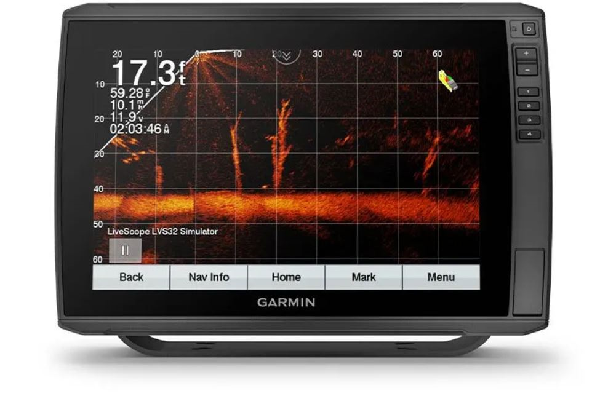
- Bundled with the powerful GT56UHD-TM transom-mount transducer, you get: Ultra High-Definition ClearVü and SideVü scanning sonar for stunningly detailed images of structure, fish, and the underwater world below and to the sides of your boat.
- Traditional CHIRP sonar for excellent target separation and depth penetration (up to 2,300 ft at 77 kHz in ideal conditions).
- High-contrast vivid color palettes to make it easier to distinguish fish, bait, and structure.
- Support for additional Garmin transducers, including Panoptix and LiveScope live-scanning options, lets you expand your fishfinding toolkit as needed.
Mapping & Navigation
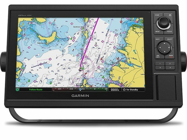
- Preloaded with a worldwide basemap (as seen above) for general global reference and orientation. Upgrade easily to premium options like Garmin Navionics+™ (detailed coastal and inland charts with daily updates) or Garmin Navionics Vision+™ for high-resolution relief shading, Auto Guidance+, and more (sold separately).
- Built-in Quickdraw Contours software lets you create personalized HD fishing maps with 1-foot contours in real time using your own sonar data. Mark and save up to 5,000 waypoints, create 100 routes, and log up to 50,000 track points for revisiting your favorite spots.
- Connectivity & Convenience Built-in Wi-Fi® for wireless software updates, sharing waypoints/routes, and connecting to the ActiveCaptain® app for OneChart™, smart notifications, and community data.
Multi-band GPS for fast, accurate positioning.
- Easy integration with NMEA 2000® networks for engine data, autopilot control, digital switching, and more.
- Whether you're chasing trophy fish on big lakes, exploring coastal waters, or navigating unfamiliar areas, the ECHOMAP Ultra 122sv provides the tools you need for success. It's the ultimate all-in-one solution for anglers who want top-tier sonar imaging, reliable GPS charting, and user-friendly operation in a large, vibrant display.
In the box
- Garmin Echomap Ultra 122sv chartplotter with worldwide basemap
- GT56UHD-TM transducer
- Power/data cable
- Mounting hardware and documentation
Specifications
- Physical Dimensions: 13.4" x 9.0" x 3.9" (341 x 229 x 98 mm)
- Weight: 5.5 lbs (2.5 kg)
- Display Size: 12.1" diagonal (10.3" x 6.4" viewable area; 26.1 cm x 16.3 cm)
- Display Resolution: 1280 x 800 pixels (WXGA)
- Display Type: Sunlight-readable touchscreen with keyed assist
- Water Rating: IPX7 (waterproof)
- Mounting Options: Bail or flush mount
- Included Transducer: GT56UHD-TM transom mount
- Preloaded Maps: Worldwide basemap (non-detailed global reference for coastlines, major bodies of water, and general orientation)
- Custom Mapping: Quickdraw Contours – create personalized 1 ft HD contour maps in real time
Waypoints, Routes & Tracks: Up to 5,000 waypoints, 100 routes, 50,000 track points - GPS: Multi-band/multi-constellation receiver (10 Hz update rate)
- Connectivity & Power Wireless: Built-in Wi-Fi® for software updates, ActiveCaptain® app integration, OneChart™, smart notifications, and data sharing
- Networking: NMEA 2000® compatible (for engine data, autopilot, digital switching, etc.)
- Card Slots: Dual microSD™ (supports optional maps and software updates)
- Power Input: 10-18 Vdc
- Power Consumption: Approximately 26 W (typical)
- Fuse: 8 A fast-blow (included)
- Other Features Temperature Range: Operating from -15°C to 55°C (5°F to 131°F)
- Additional: High-sensitivity internal GPS antenna (external option via NMEA 2000), vivid color palettes for sonar, fish and structure highlighting
Related Products
Related Products


Garmin EchoMap Ultra 2 122sv Chartplotter
Garmin


Garmin EchoMap Ultra 2 122sv with GT56UHD-TM
Garmin


Garmin EchoMap Ultra 2 102sv with GT56UHD-TM
Garmin


Garmin EchoMap Ultra 2 102sv Chartplotter
Garmin

Garmin GT56UHD-TM Transducer
Garmin