

Description
IMPORTANT – PLEASE CHECK YOUR EXACT GARMIN CHARTPLOTTER MODEL FOR BLUECHART G3 COMPATIBILITY BEFORE ORDERING. COMPATIBILITY DEPENDS ON THE CHARTPLOTTER MODEL, SOFTWARE VERSION AND SUPPORTED MEMORY-CARD FORMAT.
The Garmin BlueChart g3 HXEU004R Irish Sea chart provides detailed coastal cartography for compatible Garmin chartplotters.
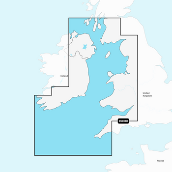
Coverage extends along the British coast from Port Ellen on the Isle of Islay to Falmouth and along the Irish coast from Sheep Haven to Caherciveen. It also includes the Isle of Man, Isles of Scilly, Belfast, Dublin and other important Irish Sea cruising areas.
BlueChart g3 combines Garmin and Navionics chart data to provide navigational aids, depth contours, tides, currents, port information and detailed coastal features.
Auto Guidance uses the vessel’s selected depth and overhead-clearance settings to calculate a suggested route. Depth Range Shading and Shallow Water Shading help identify preferred depths and potentially hazardous shallow areas.
Key Features
- Detailed Irish Sea marine cartography
- Integrated Garmin and Navionics chart data
- Auto Guidance route-planning technology
- Depth Range Shading for up to 10 depth ranges
- User-defined Shallow Water Shading
- Detailed contours down to 30cm/1ft in supported areas
- Tides and currents
- Navigational aids and coastal features
- Detailed port, marina and harbour information
- Pre-programmed chart card
- Designed for compatible Garmin chartplotters
Chart Coverage
British Coast
Coverage extends from:
- Port Ellen on the Isle of Islay
- South to Falmouth
- Isle of Man
- Isles of Scilly
- Adjacent Irish Sea coastal waters
Irish Coast
Coverage extends from:
- Sheep Haven
- Londonderry/Derry area
- Belfast
- Dublin
- South and southwest to Caherciveen
PLEASE CHECK THE OFFICIAL HXEU004R COVERAGE IMAGE TO CONFIRM THAT YOUR REQUIRED NAVIGATION AREA IS INCLUDED.
This is a regional Irish Sea chart and does not provide complete coverage of every Irish or UK coastal area.
Chartplotter Compatibility
THIS CHART IS FOR COMPATIBLE GARMIN CHARTPLOTTERS ONLY.
Compatibility depends on:
- Exact Garmin chartplotter model
- Chartplotter generation
- Installed software version
- Supported microSD/SD card format
- Support for individual BlueChart g3 features
Please provide the complete Garmin chartplotter model before ordering if compatibility is uncertain.
BlueChart g3 or BlueChart g3 Vision?
This product is the standard BlueChart g3 HXEU004R chart.
It is not the premium BlueChart g3 Vision VEU004R version and should not be advertised as including premium Vision features such as:
- High-resolution satellite imagery
- Aerial photography
- MarinerEye 3D view
- FishEye 3D view
Specifications
| Specification | Details |
|---|---|
| Manufacturer | Garmin |
| Chart Series | BlueChart g3 |
| Garmin Part Number | 010-C0763-20 |
| CH Marine SKU | G010-C0763-20 |
| Chart Code | HXEU004R |
| Chart Name | Irish Sea |
| Coverage Size | Regular |
| Card Format | microSD/SD |
| Cartography Status | Pre-programmed |
| Compatible Brand | Garmin |
| Auto Guidance | Yes, on compatible models |
| Depth Range Shading | Yes, on compatible models |
| Shallow Water Shading | Yes, on compatible models |
| Premium Vision Features | No |
What’s Included?
- 1 × Garmin BlueChart g3 HXEU004R Irish Sea microSD/SD chart card
Navigation Notice
Auto Guidance is intended for route-planning purposes only and does not replace safe navigation. Every suggested route must be checked against official navigation information, current conditions, vessel limitations and local restrictions.
Related Products
Related Products

Garmin BlueChart G3 - Ireland West Coast
Garmin

Garmin BlueChart G3 - Europe Atlantic Coast - VEU722L
Garmin
Garmin Navionics+ Chart - Irish Sea NSEU004R
Garmin


Garmin Navionics Vision+ Chart - Irish Sea
Navionics

Imray Irish Sea Pilot
Imray